Notes from the top of the world: A behind-the-scenes look at our latest Google Maps special collection
Notes from the top of the world: A behind-the-scenes look at our latest Google Maps special collection:
Today, we released photos of the some of the most famous mountains in the world on Google Maps. I was lucky to be part of the team that traveled around the world to capture the imagery and experience the mountains first-hand.
I’ve always had a sense of adventure. In 2011, when my colleague asked if I wanted to go on a trip to Everest Base Camp, I couldn’t resist, and we recruited a group of Googlers and fellow explorers to join us. Then we learned we could capture imagery of our trip for Google Maps with a tripod and a digital camera. We had plenty of room in our packs, so we loaded up our cameras and mountaineering gear, and hopped on a plane to Nepal.
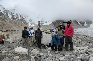
Day 8: We left early in the morning and hiked for about three hours until we reached a small village called Gorak Shep. The hike was flat along a river for several hours, then turned into a very steep climb. When we arrived at Base Camp, it was the most amazing feeling of accomplishment. We had finally made it to the base of the top of the world! We wouldn’t have gotten here without our expert guide and porters who know the mountains like the back of their hand and were essential to the success and safety of our trip. I barely stopped to enjoy the moment before wanting to accomplish the next goal - photographing the Base Camp where a real summit expedition had actually set up camp.
Posted by Sara Pelosi, People Programs Manager, on behalf of entire expedition team

Today, we released photos of the some of the most famous mountains in the world on Google Maps. I was lucky to be part of the team that traveled around the world to capture the imagery and experience the mountains first-hand.
I’ve always had a sense of adventure. In 2011, when my colleague asked if I wanted to go on a trip to Everest Base Camp, I couldn’t resist, and we recruited a group of Googlers and fellow explorers to join us. Then we learned we could capture imagery of our trip for Google Maps with a tripod and a digital camera. We had plenty of room in our packs, so we loaded up our cameras and mountaineering gear, and hopped on a plane to Nepal.
Tenzing-Hillary Airport - the most dangerous airport in the world
Our adventures began with the trek to Everest Base Camp where we spent 12 days in the mountains battling altitude sickness, an earthquake, mudslides, snow storms and flash floods. The highest altitude we reached was 18,192 feet -- higher than anywhere in the contiguous U.S. -- and we hiked more than 70 miles (or 50 hours) during the trip. We carried our camera equipment everywhere we went and captured a collection of panoramas at key camps and other interesting stops along the way. Below are a few excerpts from the journal I kept during our trip:
Buddhist mantras outside the town of Lukla
Day 2: Today we arrived at Namche Bazaar -- “the gateway to the high Himalaya.” It’s a good-sized town with lots of hotels, shops and a pharmacy. Many hikers stop here for altitude acclimatization on their way to Everest. During our stay there was a 6.9 earthquake! It was scary, especially when we realized we were in a developing country that doesn’t have infrastructure or emergency services like back home in California. We were fortunate that there was very little damage where we were.
Fisheye view of Namche Bazaar
Day 3: We woke up to a clear morning. The mountains were absolutely spectacular! We spent the day taking pictures of the town with our Street View cameras and meticulously taking notes on a map so we could remember what we were capturing once we were back at sea level. Everyone, including me, is starting to feel the effects of the altitude (mostly nausea and headaches), and we’re barely above 11,000 ft.
Googlers Sara Pelosi and Andrew Swerdlow with Ama Dablam looming in the distance
Day 4: The morning was a pretty easy walk, mostly traversing the mountain ridges. After we stopped for tea there was a long climb, "up up up" according to our guide, all on switchbacks. We stopped in Tengboche for lunch, then photographed the monastery with the fisheye lens. Amazing place. The monks watched us closely as we walked around. I don't know if they were more interested in the Americans or the photography. We continued on to Pangboche where we stayed for the night. When we got to Pangboche we saw a patch of blue sky and a rainbow. I'm still optimistic that we'll see at least a glimpse of the peak of Everest. Our guide says, "can be", which we’ve learned is the answer to every question. We're not even quite to 13,000 ft here. A long way left to go up.
The Everest trekking group with our amazing guides
We’re honored to share this amazing imagery with you on Google Maps and show the world what life is like from its highest peaks! To see more of this collection, visit the Street View Gallery or download Google Maps on your iPhone or Android device. And join us for a Hangout on Air today at 10:00 am PT where we’ll answer questions about our adventures.
Posted by Sara Pelosi, People Programs Manager, on behalf of entire expedition team


Comments