Exploring historical imagery with Google Timelapse:
The historical imagery feature of Google Earth is an amazing tool, allowing you to browse imagery from a handful of different years for any given location on earth. Google has recently been working on a project with the USGS, NASA and TIME called Timelapse, and they’ve released it as a browser-based interactive timeline of imagery for selected locations on earth.

The process for developing this is stunning. From the Google Lat Long Blog:
Additional animated GIFs can be found on their Google+ page.
You can go check it all out for yourself on the Google Timelapse page, or read more about it on TIME’s website or on the Google Lat Long Blog.
The post Exploring historical imagery with Google Timelapse appeared first on Google Earth Blog.


The historical imagery feature of Google Earth is an amazing tool, allowing you to browse imagery from a handful of different years for any given location on earth. Google has recently been working on a project with the USGS, NASA and TIME called Timelapse, and they’ve released it as a browser-based interactive timeline of imagery for selected locations on earth.
The process for developing this is stunning. From the Google Lat Long Blog:
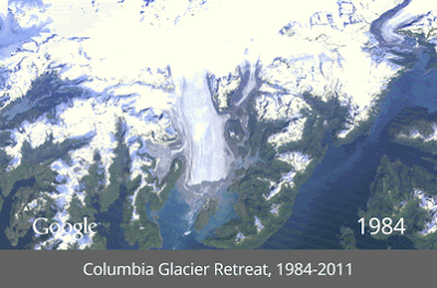
We started working with the USGS in 2009 to make this historic archive of earth imagery available online. Using Google Earth Engine technology, we sifted through 2,068,467 images—a total of 909 terabytes of data—to find the highest-quality pixels (e.g., those without clouds), for every year since 1984 and for every spot on Earth. We then compiled these into enormous planetary images, 1.78 terapixels each, one for each year.They’ve also created a handful of animated GIFs to show some of the timelapses, such as this one that features the Columbia Glacier Retreat from 1984-2011:
Additional animated GIFs can be found on their Google+ page.
You can go check it all out for yourself on the Google Timelapse page, or read more about it on TIME’s website or on the Google Lat Long Blog.
The post Exploring historical imagery with Google Timelapse appeared first on Google Earth Blog.
Comments